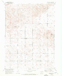
1952 Map of Marks Butte
USGS Topo · Published 1972About this map
Marks Butte stands as the primary landmark in this section of Sedgwick County, overlooking a landscape defined by isolated agricultural outposts and necessary water infrastructure. The terrain is dotted with dozens of Windmill sites, essential for sustaining life and livestock in this corner of the High Plains during the early 1950s. Settlement is sparse, anchored by the Price Ranch and the site of the Sunrise School (Aband), reflecting the consolidation of rural education as the era progressed. These survey details, compiled for the Department of the Interior's Missouri River Basin development program, capture a moment when traditional ranching relied on a high density of small-scale water improvements across the township lines of T. 10 N. and T. 9 N. in the northeastern corner of the state.
Find a feature on this map
6 named features on this map. Tap any name to fly to it.
Don’t see what you’re looking for? This feature index may not catch every label — zoom into the map to look around manually.
Map Details
Editions of this 1952 Marks Butte Map
2 editions found
Other maps of this area

1952 · Julesburg SW
USGS Topo · 1:24,000

1952 · Marks Butte
USGS Topo · 1:24,000

1953 · Ovid
USGS Topo · 1:24,000

1953 · Tamarack Ranch
USGS Topo · 1:24,000

1953 · Julesburg Reservoir
USGS Topo · 1:24,000

1953 · Sedgwick
USGS Topo · 1:24,000

1954 · Sterling
USGS Topo · 1:250,000

1958 · Sterling
USGS Topo · 1:250,000

1962 · Haxtun East
USGS Topo · 1:24,000

1962 · Haxtun West
USGS Topo · 1:24,000