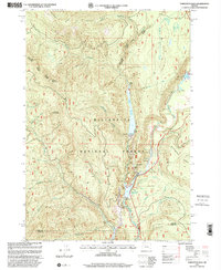
1997 Map of Tamolitch Falls
USGS Topo · Published 2001About this map
The Mc Kenzie River corridor within the Willamette National Forest defines this landscape of high ridges and managed waterways. By the late 1990s, the area reflects a sophisticated balance of hydroelectric infrastructure and recreational use. A series of reservoirs, including the Smith River Reservoir and Trail Bridge Reservoir, dominate the central drainage, supported by the Smith Dam and the Spillway Powerplant. These features represent the mid-century development of the McKenzie River’s upper reaches for power generation.
Find a feature on this map
30 named features on this map. Tap any name to fly to it.
Don’t see what you’re looking for? This feature index may not catch every label — zoom into the map to look around manually.
Map Details
Editions of this 1997 Tamolitch Falls Map
This is the sole edition of this map. No revisions or reprints were ever made.
Other maps of this area

1929 · Three Sisters
USGS Topo · 1:125,000

1932 · Three Sisters
USGS Topo · 1:125,000

1934 · Mc Kenzie Bridge
USGS Topo · 1:96,000

1940 · Mc Kenzie Bridge
USGS Topo · 1:125,000

1953 · Salem
USGS Topo · 1:250,000

1954 · Salem
USGS Topo · 1:250,000

1955 · Echo Mountain
USGS Topo · 1:62,500

1955 · Mc Kenzie Bridge
USGS Topo · 1:62,500

1955 · Bend
USGS Topo · 1:250,000

1957 · Bend
USGS Topo · 1:250,000