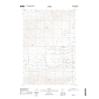
2020 Map of Tampico
USGS Topo · Published 2020About this map
Tampico serves as the focal point of this Yakima County landscape, situated where the N Fork Ahtanum Cr and S Fork Ahtanum Cr converge to form Ahtanum Cr. The topography is defined by the significant rise of Cowiche Mtn to the north and the prominent Ahtanum Ridge to the south, framing the productive Ahtanum Valley. This map captures a complex network of agricultural water management essential to the region's development, featuring the Ahtanum Canal and several named irrigation channels like Lesh Ditch, Shaw-Knox Ditch, and John Cox Ditch. These waterways support the valley's rural economy, which is further evidenced by local aviation sites such as West Valley Airport and Wilkinson Ranch Airport. The northern reaches include the higher elevations of Cowiche Basin and the isolated Oak Spring, illustrating the transition from the irrigated valley floor to the high rangeland.
Find a feature on this map
60 named features on this map. Tap any name to fly to it.
Don’t see what you’re looking for? This feature index may not catch every label — zoom into the map to look around manually.
Map Details
Editions of this 2020 Tampico Map
This is the sole edition of this map. No revisions or reprints were ever made.
Other maps of this area

1899 · Ellensburg
USGS Topo · 1:125,000

1901 · Ellensburg
USGS Topo · 1:125,000

1937 · White Swan
USGS Topo · 1:125,000

1950 · Yakima
USGS Topo · 1:250,000

1957 · Yesmowit Canyon
USGS Topo · 1:24,000

1958 · Fort Simcoe
USGS Topo · 1:62,500

1958 · Wiley City
USGS Topo · 1:24,000

1958 · White Swan
USGS Topo · 1:24,000
1958 · Medicine Valley
USGS Topo · 1:24,000

1958 · Naches
USGS Topo · 1:24,000