
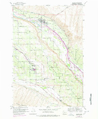
1958 Map of Naches
USGS Topo · Published 1960About this map
Naches River irrigation networks define this Yakima County landscape, where the Tieton Canal, Upper Selah Valley Canal, and Wapatox Canal support a burgeoning agricultural region. The Northern Pacific railroad tracks trace the river valley, serving the town of Naches and smaller outposts like Eschbach and Weikel. This 1950s survey captures a transition in local education, documenting several rural school sites including the Highland High Sch and Marcus Whitman-Cowiche Sch near Cowiche. The terrain transitions from the river bottom to the high ground of Naches Heights and Cowiche Mountain, revealing a complex system of local roads often named after early families, such as Holzinger Road and Rosenkranz Road. Landmarks like the Grange Hall and various powerhouses highlight the community's mid-century infrastructure.
Find a feature on this map
57 named features on this map. Tap any name to fly to it.
Don’t see what you’re looking for? This feature index may not catch every label — zoom into the map to look around manually.
Map Details
Editions of this 1958 Naches Map
2 editions found
Other maps of this area

1899 · Ellensburg
USGS Topo · 1:125,000

1901 · Ellensburg
USGS Topo · 1:125,000

1950 · Yakima
USGS Topo · 1:250,000

1958 · Ellensburg
USGS Topo · 1:62,500
1958 · Yakima West
USGS Topo · 1:24,000
1958 · Selah
USGS Topo · 1:24,000

1958 · Wiley City
USGS Topo · 1:24,000

1958 · Yakima
USGS Topo · 1:250,000

1961 · Yakima
USGS Topo · 1:250,000
1971 · Milk Canyon
USGS Topo · 1:24,000