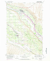
1958 Map of Naches
USGS Topo · Published 1978About this map
Naches River and its intricate network of irrigation ditches define this Yakima County landscape, showing a region deeply tied to water management and agriculture. The map illustrates how essential systems like the Wapatox Canal, Selah Valley Canal, and the Old Naches Flume have historically distributed water through the Naches Valley and across Naches Heights. The settlement patterns are concentrated along these routes, featuring smaller communities like Cowiche, Holtzinger, and Eschbach alongside the main hub at Naches. The influence of transportation and industry is evident in the path of the Burlington Northern railroad and several schools serving the rural population, including the Marcus Whitman-Cowiche Sch and Highland High Sch. This detailed view captures the transition from river-bottom farming to high-plateau orcharding and ranching.
Find a feature on this map
50 named features on this map. Tap any name to fly to it.
Don’t see what you’re looking for? This feature index may not catch every label — zoom into the map to look around manually.
Map Details
Editions of this 1958 Naches Map
2 editions found
Other maps of this area

1899 · Ellensburg
USGS Topo · 1:125,000

1901 · Ellensburg
USGS Topo · 1:125,000

1950 · Yakima
USGS Topo · 1:250,000

1958 · Ellensburg
USGS Topo · 1:62,500
1958 · Yakima West
USGS Topo · 1:24,000
1958 · Selah
USGS Topo · 1:24,000

1958 · Wiley City
USGS Topo · 1:24,000

1958 · Naches
USGS Topo · 1:24,000

1958 · Yakima
USGS Topo · 1:250,000

1961 · Yakima
USGS Topo · 1:250,000