
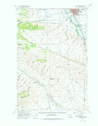
1958 Map of Ellensburg
USGS Topo · Published 1960About this map
Ellensburg serves as the focal point of this late 1950s survey, where the Northern Pacific railroad tracks and the Yakima River parallel each other through the valley floor. The map documents an era of post-war infrastructure, featuring a Drive-in Theater and Sewage Treatment facility near the city limits, while the surrounding landscape is defined by the massive folds of Manastash Ridge and Umtanum Ridge.
Find a feature on this map
43 named features on this map. Tap any name to fly to it.
Don’t see what you’re looking for? This feature index may not catch every label — zoom into the map to look around manually.
Map Details
Editions of this 1958 Ellensburg Map
2 editions found
Other maps of this area

1897 · Mount Stuart
USGS Topo · 1:125,000

1899 · Ellensburg
USGS Topo · 1:125,000

1901 · Ellensburg
USGS Topo · 1:125,000

1902 · Mount Stuart
USGS Topo · 1:125,000

1920 · Colockum Pass
USGS Topo · 1:125,000

1922 · Colockum Pass
USGS Topo · 1:125,000

1936 · Yakima East
USGS Topo · 1:48,000

1938 · Badger Pocket
USGS Topo · 1:48,000

1941 · Yakima East
USGS Topo · 1:62,500

1943 · Badger Pocket
USGS Topo · 1:62,500