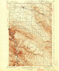
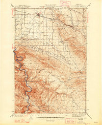
1943 Map of Badger Pocket
USGS Topo · Published 1943About this map
The Kittitas Valley is defined here by an intricate network of irrigation engineering and rail infrastructure during the mid-1930s. The Chicago Milwaukee St. Paul and Pacific railroad cuts across the northern landscape, serving agricultural hubs like Kittitas and East Kittitas, while gravity-defying water works such as the Cascade Canal, Town Canal, and Gravity Ditch illustrate the intensive transformation of this arid region into productive farmland.
Find a feature on this map
50 named features on this map. Tap any name to fly to it.
Don’t see what you’re looking for? This feature index may not catch every label — zoom into the map to look around manually.
Map Details
Editions of this 1943 Badger Pocket Map
2 editions found
Other maps of this area

1897 · Mount Stuart
USGS Topo · 1:125,000

1899 · Ellensburg
USGS Topo · 1:125,000

1901 · Ellensburg
USGS Topo · 1:125,000

1902 · Mount Stuart
USGS Topo · 1:125,000

1920 · Colockum Pass
USGS Topo · 1:125,000

1922 · Colockum Pass
USGS Topo · 1:125,000

1936 · Yakima East
USGS Topo · 1:48,000

1936 · Hog Ranch Buttes
USGS Topo · 1:48,000

1938 · Badger Pocket
USGS Topo · 1:48,000

1939 · Boylston
USGS Topo · 1:48,000