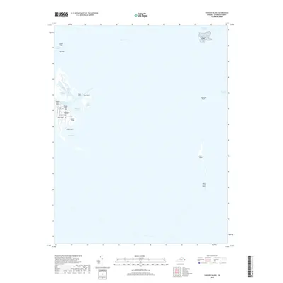
2019 Map of Tangier Island
USGS Topo · Published 2019About this map
Tangier serves as the focal point of this coastal survey, appearing as a resilient settlement amidst the shifting waters of Tangier Sound and Pocomoke Sound. The community's unique geography is defined by a series of narrow ridges, including Main Ridge, West Ridge, and Canton Ridge, which provide the primary habitable ground. The map details the intricate maritime landscape, from the vital North Channel to the protected waters of Mailboat Harbor and Cod Harbor. Remote landforms like Watts Island and the Little Fox Islands stand as markers of the Chesapeake's evolving coastline. The presence of the Tangier Island Airport and Long Bridge Rd illustrates the essential infrastructure connecting this isolated island to the mainland, while labels like The Shells and East Point Marsh highlight the delicate environment surrounding the town.
Find a feature on this map
27 named features on this map. Tap any name to fly to it.
Don’t see what you’re looking for? This feature index may not catch every label — zoom into the map to look around manually.
Map Details
Editions of this 2019 Tangier Island Map
This is the sole edition of this map. No revisions or reprints were ever made.
Other maps of this area

1903 · Crisfield
USGS Topo · 1:62,500

1917 · Ewell
USGS Topo · 1:62,500

1920 · Crisfield
USGS Topo · 1:62,500

1942 · Chesconessex
USGS Topo · 1:31,680

1942 · Nandua Creek
USGS Topo · 1:24,000

1942 · Ewell
USGS Topo · 1:24,000

1942 · Great Fox Island
USGS Topo · 1:24,000

1942 · Tangier Island
USGS Topo · 1:24,000
1943 · Ewell
USGS Topo · 1:31,680

1943 · Pungoteague
USGS Topo · 1:31,680