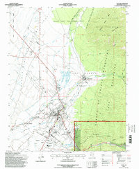
1995 Map of Taos
USGS Topo · Published 1998About this map
Taos Pueblo and the surrounding high desert terrain anchor this mid-1990s survey, illustrating a landscape defined by centuries of communal land management and irrigation. The complex network of water rights is visible through numerous named acequias, including the Acequia Madre del Prado and Acequia del Medio, which have historically sustained the valley's agriculture. The map captures the interface between the Sangre de Cristo Mountains and the valley floor, where the Carson National Forest meets the historic Spanish land grants like the Antoine Leroux Grant and the Fernando de Taos Grant. For genealogists and local historians, the sheet is exceptionally rich in burial sites, documenting the Kit Carson Cem, Los Cruces Cem, and Water Tank Los Dolores Cem. The proximity of Taos to El Prado and Ranchito reveals a settlement pattern that follows the life-giving flow of the Rio Pueblo de Taos.
Find a feature on this map
56 named features on this map. Tap any name to fly to it.
Don’t see what you’re looking for? This feature index may not catch every label — zoom into the map to look around manually.
Map Details
Editions of this 1995 Taos Map
This is the sole edition of this map. No revisions or reprints were ever made.
Other maps of this area

1954 · Raton
USGS Topo · 1:250,000

1958 · Raton
USGS Topo · 1:250,000

1963 · Wheeler Peak
USGS Topo · 1:24,000

1963 · Arroyo Seco
USGS Topo · 1:24,000

1963 · Arroyo Hondo
USGS Topo · 1:24,000

1964 · Los Cordovas
USGS Topo · 1:24,000

1964 · Taos
USGS Topo · 1:24,000

1964 · Ranchos De Taos
USGS Topo · 1:24,000

1964 · Taos SW
USGS Topo · 1:24,000

1965 · Pueblo Peak
USGS Topo · 1:24,000