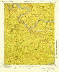
1941 Map of Tapoco
USGS Topo · Published 1941About this map
Calderwood Dam and Che Oah Dam anchor this mountain landscape, marking a period of significant hydroelectric development by the Tennessee Valley Authority. The map details the complex water systems of the Little Tennessee River and Che Oah Lake, including the massive Hydro-Electric Tunnel network. Amidst the protected lands of the Great Smoky Mountains National Park and Nantahala National Forest, the topography shows isolated human footprints like the Bethel Ch and Beers Sch. Genealogical researchers can locate family sites such as Farley Cem and Orr Cem tucked into the steep ridges. The Appalachian Trail winds through the high ground at Deals Gap, while a solitary Gold Mine and the community of Tapoco hint at the diverse economic history of these high mountain gaps.
Find a feature on this map
123 named features on this map. Tap any name to fly to it.
Don’t see what you’re looking for? This feature index may not catch every label — zoom into the map to look around manually.
Map Details
Editions of this 1941 Tapoco Map
This is the sole edition of this map. No revisions or reprints were ever made.
Other maps of this area

1886 · Knoxville
USGS Topo · 1:125,000

1892 · Knoxville
USGS Topo · 1:125,000

1893 · Murphy
USGS Topo · 1:125,000

1894 · Knoxville
USGS Topo · 1:125,000

1895 · Loudon
USGS Topo · 1:125,000

1895 · Knoxville
USGS Topo · 1:125,000

1901 · Knoxville
USGS Topo · 1:125,000

1914 · Murphy
USGS Topo · 1:125,000

1927 · Big Junction
USGS Topo · 1:24,000

1933 · Haw Knob
USGS Topo · 1:48,000