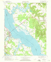
1968 Map of Tappahannock
USGS Topo · Published 1971About this map
The Rappahannock River serves as the central artery for this coastal Virginia landscape, physically dividing Essex and Richmond counties. The Downing Bridge provides the primary crossing between the town of Tappahannock and the inland settlement of Warsaw. This era shows a community deeply tied to its riverine geography, featuring several waterfront locales such as Naylors Beach, Richmond Beach, and Fairview. Along the banks, named points like Naylors Point, Mangoright Point, and Lowery Point define the meandering shoreline.
Find a feature on this map
43 named features on this map. Tap any name to fly to it.
Don’t see what you’re looking for? This feature index may not catch every label — zoom into the map to look around manually.
Map Details
Editions of this 1968 Tappahannock Map
4 editions found
Other maps of this area

1892 · Piney Point
USGS Topo · 1:62,500

1892 · Montross
USGS Topo · 1:62,500

1894 · Piney Point
USGS Topo · 1:62,500

1895 · Nomini
USGS Topo · 1:125,000

1895 · Piney Point
USGS Topo · 1:62,500

1895 · Montross
USGS Topo · 1:62,500

1898 · Nomini
USGS Topo · 1:125,000

1901 · Piney Point
USGS Topo · 1:62,500

1917 · Morattico
USGS Topo · 1:62,500

1918 · Tappahannock
USGS Topo · 1:62,500