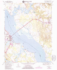
1968 Map of Tappahannock
USGS Topo · Published 1985About this map
Tappahannock serves as the focal point of this riverfront landscape, situated where the broad Rappahannock River is spanned by the Downing Bridge. The town's character is defined by its maritime and civic infrastructure, including the Tappahannock Municipal Airport and St Margarets Ch, while the riverfront is dotted with recreation spots like Coleman Island and Richmond Beach. Across the water in Richmond County, the town of Warsaw sits inland from the tidal flats, connected to the river via winding waterways like Little Carter Creek and Cat Point Creek. The inland geography is marked by historic millponds, such as Mt Airy Millpond and Connellee Millpond, which reflect the early agrarian and industrial heritage of the Virginia Tidewater. Smaller landings and family-named points like Side Landing and Jones Point Tidal Flat suggest a long-standing reliance on the river for transport and commerce.
Find a feature on this map
53 named features on this map. Tap any name to fly to it.
Don’t see what you’re looking for? This feature index may not catch every label — zoom into the map to look around manually.
Map Details
Editions of this 1968 Tappahannock Map
4 editions found
Other maps of this area

1892 · Piney Point
USGS Topo · 1:62,500

1892 · Montross
USGS Topo · 1:62,500

1894 · Piney Point
USGS Topo · 1:62,500

1895 · Nomini
USGS Topo · 1:125,000

1895 · Piney Point
USGS Topo · 1:62,500

1895 · Montross
USGS Topo · 1:62,500

1898 · Nomini
USGS Topo · 1:125,000

1901 · Piney Point
USGS Topo · 1:62,500

1917 · Morattico
USGS Topo · 1:62,500

1918 · Tappahannock
USGS Topo · 1:62,500