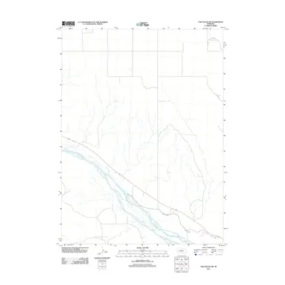
2011 Map of Tar Valley SW
USGS Topo · Published 2011About this map
The braided channels of the North Platte River dominate the southern landscape of this Garden County region, illustrating the complex hydrology of Nebraska's Platte Valley. Paralleling the river's course, the Lisco Canal serves as a critical piece of agricultural infrastructure, diverted to manage water across the wide valley floor. The upland terrain to the north is defined by a sparse network of section-line roads, including Road 149 and Road 88, which navigate the open country above the river breaks. This 2011 survey captures the area's transition from the river's alluvial plain to the higher plains, showing how transportation routes like Road 82 follow the natural contours of the valley's edge.
Find a feature on this map
5 named features on this map. Tap any name to fly to it.
Don’t see what you’re looking for? This feature index may not catch every label — zoom into the map to look around manually.
Map Details
Editions of this 2011 Tar Valley SW Map
This is the sole edition of this map. No revisions or reprints were ever made.
Other maps of this area

1896 · Browns Creek
USGS Topo · 1:125,000

1899 · Browns Creek
USGS Topo · 1:125,000

1899 · Sidney
USGS Topo · 1:125,000

1954 · Scottsbluff
USGS Topo · 1:250,000

1958 · Scottsbluff
USGS Topo · 1:250,000

1965 · Broadwater
USGS Topo · 1:24,000

1965 · Broadwater NE
USGS Topo · 1:24,000

1971 · Richardson Lake
USGS Topo · 1:24,000

1971 · Tar Valley SW
USGS Topo · 1:24,000
1971 · Buske Ranch
USGS Topo · 1:24,000