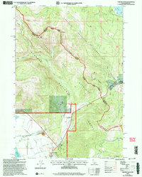
2000 Map of Targhee Pass
USGS Topo · Published 2005About this map
Continental Divide crests through this high-altitude borderland, marking the dramatic boundary between Gallatin County, Montana, and Fremont County, Idaho. The landscape is dominated by the Henrys Lake Mountains, where peaks like Lionhead and Bald Peak overlook the headwaters of both the West Fork Gallatin River and Targhee Creek. This 2000 revision shows a region primarily defined by its transition from high mountain wilderness to the valley floor of Henrys Lake, featuring the Landing Field and Targhee Cemetery near the shoreline.
Find a feature on this map
54 named features on this map. Tap any name to fly to it.
Don’t see what you’re looking for? This feature index may not catch every label — zoom into the map to look around manually.
Map Details
Editions of this 2000 Targhee Pass Map
This is the sole edition of this map. No revisions or reprints were ever made.
Other maps of this area

1950 · Hebgen Dam
USGS Topo · 1:62,500

1955 · Ashton
USGS Topo · 1:250,000

1958 · Ashton
USGS Topo · 1:250,000

1958 · West Yellowstone
USGS Topo · 1:62,500
1958 · Tepee Creek
USGS Topo · 1:62,500

1960 · Ashton
USGS Topo · 1:250,000

1964 · Targhee Pass
USGS Topo · 1:24,000

1964 · Targhee Peak
USGS Topo · 1:24,000

1964 · Sawtell PK
USGS Topo · 1:24,000

1964 · Big Springs
USGS Topo · 1:24,000