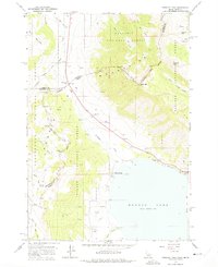
1964 Map of Targhee Peak
USGS Topo · Published 1975About this map
The Continental Divide serves as the high-altitude spine of this mid-1960s survey, marking the intersection of the Idaho and Montana state lines. The landscape is dominated by the northern shores of Henrys Lake, a focal point for both hydrology and local industry. Evidence of the area's development is found in the concentrated settlement patterns around Staley Springs and the nearby Fish Hatchery, indicating the importance of the lake to the local economy.
Find a feature on this map
41 named features on this map. Tap any name to fly to it.
Don’t see what you’re looking for? This feature index may not catch every label — zoom into the map to look around manually.
Map Details
Editions of this 1964 Targhee Peak Map
2 editions found
Other maps of this area

1950 · Cliff Lake
USGS Topo · 1:62,500

1950 · Hebgen Dam
USGS Topo · 1:62,500

1950 · Upper Red Rock Lake
USGS Topo · 1:62,500

1955 · Ashton
USGS Topo · 1:250,000

1958 · Ashton
USGS Topo · 1:250,000

1960 · Ashton
USGS Topo · 1:250,000

1964 · Targhee Pass
USGS Topo · 1:24,000

1964 · Targhee Peak
USGS Topo · 1:24,000

1964 · Sawtell PK
USGS Topo · 1:24,000

1964 · Big Springs
USGS Topo · 1:24,000