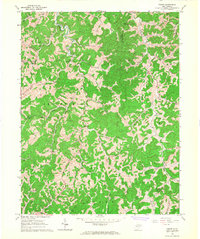
1966 Map of Tariff
USGS Topo · Published 1968About this map
Henry Fork meanders through the central ridges of Roane and Calhoun counties, anchoring a landscape defined by its deep hollows and narrow watercourses. This mid-1960s environment is dominated by an active extractive economy, with numerous Gas Wells and Oil Wells peppered across the hillsides near Linden and Tariff. Small agrarian communities and family-named landmarks are scattered throughout, including Clover and Milo, which are connected by winding valley roads that follow the path of Orchard Run and Sams Fork.
Find a feature on this map
46 named features on this map. Tap any name to fly to it.
Don’t see what you’re looking for? This feature index may not catch every label — zoom into the map to look around manually.
Map Details
Editions of this 1966 Tariff Map
2 editions found
Other maps of this area

1906 · Otter
USGS Topo · 1:62,500

1906 · Walton
USGS Topo · 1:62,500

1907 · Otter
USGS Topo · 1:62,500

1907 · Arnoldsburg
USGS Topo · 1:62,500

1907 · Spencer
USGS Topo · 1:62,500

1907 · Walton
USGS Topo · 1:62,500

1925 · Arnoldsburg
USGS Topo · 1:62,500

1927 · Arnoldsburg
USGS Topo · 1:62,500

1928 · Spencer
USGS Topo · 1:62,500

1954 · Charleston
USGS Topo · 1:250,000