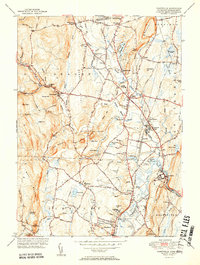
1951 Map of Tariffville
USGS Topo · Published 1951About this map
Salmon Brook and its various branches carve through the landscape of northern Hartford County, defining the settlement patterns of Granby and Simsbury during the mid-century. The New Haven and Hartford RR provides a critical industrial spine, passing through Granby Station and near the developing center at Tariffville. This era shows a community in transition, where legacy agricultural features like the Great Marsh and Beaverdam Marsh persist alongside modern developments such as the Simsbury Landing Field.
Find a feature on this map
90 named features on this map. Tap any name to fly to it.
Don’t see what you’re looking for? This feature index may not catch every label — zoom into the map to look around manually.
Map Details
Editions of this 1951 Tariffville Map
2 editions found
Other maps of this area

1886 · Springfield
USGS Topo · 1:62,500

1887 · Granville
USGS Topo · 1:62,500

1889 · Springfield
USGS Topo · 1:62,500

1889 · Granville
USGS Topo · 1:62,500

1892 · Hartford
USGS Topo · 1:62,500

1892 · Granby
USGS Topo · 1:62,500

1893 · Springfield
USGS Topo · 1:62,500

1893 · Granville
USGS Topo · 1:62,500

1895 · Springfield
USGS Topo · 1:62,500

1895 · Granville
USGS Topo · 1:62,500