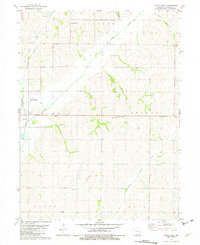
1981 Map of Tarkio East
USGS Topo · Published 1982About this map
Tarkio River and its various tributaries, including Middle Tarkio Creek and Little Tarkio Creek, define the landscape of Atchison County in the early 1980s. The town of Tarkio serves as a local hub, situated near the Burlington Northern railroad line and the Gould-Peterson Municipal Airport. The map highlights a rural infrastructure of small settlements and civic landmarks, from the Community Hall in Colfax to the Oil Field operations near Long Branch. Genealogists will find particular value in the clearly marked Center Grove Cem and Prairie Hill Cem. This topography shows the transition between the rolling uplands of Lincoln and Colfax townships and the fertile bottomlands where the river system converges. Smaller locales like Wells, York, and Center View are preserved here alongside the essential Radio Tower and Substation facilities that powered the regional economy.
Find a feature on this map
23 named features on this map. Tap any name to fly to it.
Don’t see what you’re looking for? This feature index may not catch every label — zoom into the map to look around manually.
Map Details
Editions of this 1981 Tarkio East Map
This is the sole edition of this map. No revisions or reprints were ever made.
Other maps of this area

1936 · Fairfax
USGS Topo · 1:24,000

1939 · Tarkio
USGS Topo · 1:62,500

1939 · Farragut
USGS Topo · 1:62,500

1939 · Skidmore
USGS Topo · 1:62,500

1940 · Tarkio
USGS Topo · 1:62,500

1940 · Farragut
USGS Topo · 1:62,500

1940 · Coin
USGS Topo · 1:62,500

1941 · Tarkio
USGS Topo · 1:62,500

1941 · Skidmore
USGS Topo · 1:62,500

1942 · Skidmore
USGS Topo · 1:62,500