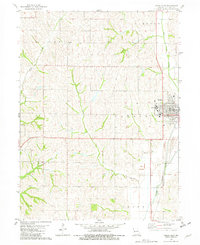
1981 Map of Tarkio West
USGS Topo · Published 1982About this map
The town of Tarkio serves as the focal point of this northwest Missouri landscape, situated where the Burlington Northern railroad lines track alongside the Tarkio River. This 1981 survey documents the community at a significant moment, showing the campus of Tarkio College and the local High Sch before major institutional changes in the following decade. The surrounding terrain is defined by the drainage patterns of West Tarkio Creek, Rock Creek, and Cow Branch, which carve through the agricultural townships of Polk, Lincoln, and Clark. Notable local landmarks include the Home Cemetery on the southeastern edge of town and a Radio Tower to the west, providing specific points of reference for genealogists and local historians studying the late twentieth-century layout of Atchison County.
Find a feature on this map
16 named features on this map. Tap any name to fly to it.
Don’t see what you’re looking for? This feature index may not catch every label — zoom into the map to look around manually.
Map Details
Editions of this 1981 Tarkio West Map
This is the sole edition of this map. No revisions or reprints were ever made.
Other maps of this area

1915 · Nemaha
USGS Topo · 1:62,500

1936 · Fairfax
USGS Topo · 1:24,000

1939 · Tarkio
USGS Topo · 1:62,500

1939 · Farragut
USGS Topo · 1:62,500

1939 · Hamburg
USGS Topo · 1:62,500

1939 · Nemaha
USGS Topo · 1:62,500

1940 · Tarkio
USGS Topo · 1:62,500

1940 · Farragut
USGS Topo · 1:62,500

1941 · Tarkio
USGS Topo · 1:62,500

1941 · Hamburg
USGS Topo · 1:62,500