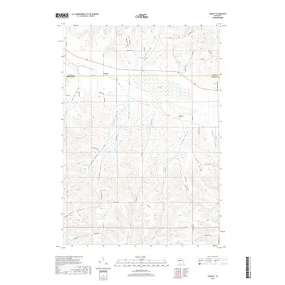
2018 Map of Tarrant
USGS Topo · Published 2018About this map
Tarrant sits at the northern edge of this Buffalo and Pepin County landscape, a region defined by a dense network of coulees and valleys that drain toward the Bear Cr and Tiffany Cr systems. The terrain is deeply incised, creating a series of distinct geographic pockets such as Newton Valley, Schultz Valley, and Steinke Valley. Near the center of the map, the Bear Creek Swamp marks a significant hydrological feature where the drainage slows amidst the surrounding ridges. For those researching local history, the Sacred Heart Cem stands as a primary landmark in the eastern portion of the quadrangle. The map details a rural infrastructure of county highways and local roads, including Co HWY B and Co HWY V, which navigate the winding valley floors and steep ridges of the Brunner Coulee and Tiffany Valley.
Find a feature on this map
63 named features on this map. Tap any name to fly to it.
Don’t see what you’re looking for? This feature index may not catch every label — zoom into the map to look around manually.
Map Details
Editions of this 2018 Tarrant Map
This is the sole edition of this map. No revisions or reprints were ever made.
Other maps of this area

1929 · Durand
USGS Topo · 1:62,500

1932 · Gilmanton
USGS Topo · 1:62,500

1932 · Durand
USGS Topo · 1:62,500

1932 · Alma
USGS Topo · 1:62,500

1932 · Mondovi
USGS Topo · 1:62,500

1950 · Alma
USGS Topo · 1:62,500

1953 · Eau Claire
USGS Topo · 1:250,000

1958 · Eau Claire
USGS Topo · 1:250,000

1964 · Eau Claire
USGS Topo · 1:250,000
1972 · Meridean
USGS Topo · 1:24,000