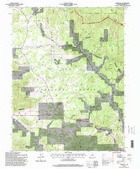
1994 Map of Tarryall
USGS Topo · Published 1998About this map
Tarryall (Puma City) sits at the northern edge of this landscape, a place where late 19th-century mining ambitions met the high mountain terrain of Park County. The map details the complex topography of the Pike National Forest, where the geological formation known as China Wall and the heights of Tappan Mountain dominate the relief. This mid-1990s revision reveals a transition from industrial activity to conservation, with the Wilderness Boundary of the Lost Creek Wilderness cutting across the northeast corner near Pilot Peak. Scattered ranching outposts like Landis Ranch and Watkins Ranch anchor the lower drainages along Tarryall Creek, while remnants of mineral exploration appear in labels for the Boomer Mine and various prospects found throughout the gulches and draws. A lonely Landing Strip and the tiny settlement of Thorpe emphasize the area's isolation during this era.
Find a feature on this map
26 named features on this map. Tap any name to fly to it.
Don’t see what you’re looking for? This feature index may not catch every label — zoom into the map to look around manually.
Map Details
Editions of this 1994 Tarryall Map
This is the sole edition of this map. No revisions or reprints were ever made.
Other maps of this area

1893 · Platte Canyon
USGS Topo · 1:125,000

1894 · Pikes Peak
USGS Topo · 1:125,000

1901 · Pikes Peak
USGS Topo · 1:125,000

1953 · Denver
USGS Topo · 1:250,000

1954 · Pueblo
USGS Topo · 1:250,000

1956 · Mc Curdy Mountain
USGS Topo · 1:24,000

1956 · Tarryall
USGS Topo · 1:24,000

1956 · Hackett Mountain
USGS Topo · 1:24,000

1956 · Lake George
USGS Topo · 1:24,000

1956 · Elevenmile Canyon
USGS Topo · 1:24,000