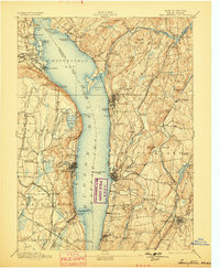
1893 Map of Tarrytown
USGS Topo · Published 1899About this map
The Hudson River dominates this late-nineteenth-century landscape, widening into the Tappan Sea and Haverstraw Bay. On the eastern shore, the State Prison at Ossining stands near the water, while a dense network of transit infrastructure, including the New York Central and Hudson River Railroad and the Croton Aqueduct, traces the riverbank. This era of engineering is further represented by the Croton Dam and the Kensico Reservoir, vital links in the region's hydraulic development. On the western side, the West Shore Railroad skirts the base of prominent heights like High Tor and Hook Mt, connecting riverfront settlements from Nyack to Haverstraw. The map illustrates a period of industrial and residential growth, where rural hamlets such as Bardon and Merritts Corners exist alongside burgeoning river towns and significant rail corridors.
Find a feature on this map
137 named features on this map. Tap any name to fly to it.
Don’t see what you’re looking for? This feature index may not catch every label — zoom into the map to look around manually.
Map Details
Editions of this 1893 Tarrytown Map
3 editions found

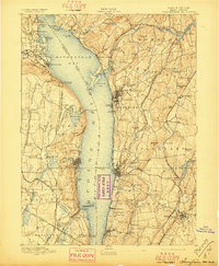
Other maps of this area

1888 · Paterson
USGS Topo · 1:62,500

1891 · Ramapo
USGS Topo · 1:62,500

1891 · Harlem
USGS Topo · 1:62,500

1892 · Stamford
USGS Topo · 1:62,500

1892 · West Point
USGS Topo · 1:62,500

1892 · Carmel
USGS Topo · 1:62,500

1892 · Paterson
USGS Topo · 1:62,500

1892 · Tarrytown
USGS Topo · 1:62,500

1893 · Carmel
USGS Topo · 1:62,500

1893 · Stamford
USGS Topo · 1:62,500