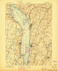
1893 Map of Tarrytown
USGS Topo · Published 1897About this map
The Hudson River dominates this nineteenth-century survey, dividing the landscape at the wide Tappan Sea and Haverstraw Bay. On the eastern shore, the infrastructure of New York's water supply is clearly delineated by the Croton Aqueduct and New Croton Aqueduct as they snake southward from the Croton Dam. This era of the Lower Hudson Valley is defined by a dense rail network, with the West Shore Railroad tracing the base of cliffs like Verdrietege Hook while the New York Central and Hudson River Railroad hugs the eastern riverbank through Ossining.
Find a feature on this map
136 named features on this map. Tap any name to fly to it.
Don’t see what you’re looking for? This feature index may not catch every label — zoom into the map to look around manually.
Map Details
Editions of this 1893 Tarrytown Map
3 editions found

Other maps of this area

1888 · Paterson
USGS Topo · 1:62,500

1891 · Ramapo
USGS Topo · 1:62,500

1891 · Harlem
USGS Topo · 1:62,500

1892 · Stamford
USGS Topo · 1:62,500

1892 · West Point
USGS Topo · 1:62,500

1892 · Carmel
USGS Topo · 1:62,500

1892 · Paterson
USGS Topo · 1:62,500

1892 · Tarrytown
USGS Topo · 1:62,500

1893 · Carmel
USGS Topo · 1:62,500

1893 · Stamford
USGS Topo · 1:62,500