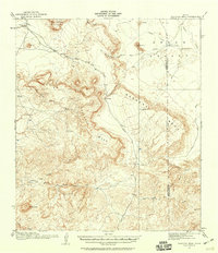
1917 Map of Tascotal Mesa
USGS Topo · Published 1959About this map
San Jacinto Mountain and the high desert plateaus of the Big Bend region dominate this 1917 survey. The landscape is defined by the massive escarpments of Tascotal Mesa and Bandera Mesa, which are navigated by narrow passages such as Wire Gap and Smugglers Gap. Early ranching life is evident through isolated outposts like the San Jacinto Ranch, Rooney Ranch, and Cotter Ranch, which relied on scarce water sources like Alazan Spring and Alamo de Cesario Creek. The map documents a critical transportation network of the era, including the Marfa and Lajitas Road and ancient routes like the Seminole Trail. These paths provided the only reliable transit through the complex topography of Green Valley and the Alazan Hills, connecting remote cattle operations to the outside world before the modernization of the Texas backcountry.
Find a feature on this map
32 named features on this map. Tap any name to fly to it.
Don’t see what you’re looking for? This feature index may not catch every label — zoom into the map to look around manually.
Map Details
Editions of this 1917 Tascotal Mesa Map
2 editions found
Other maps of this area

1896 · Polvo
USGS Topo · 1:125,000

1896 · Shafter
USGS Topo · 1:125,000

1903 · Terlingua
USGS Topo · 1:125,000

1904 · Terlingua
USGS Topo · 1:125,000

1917 · Agua Fria
USGS Topo · 1:62,500

1917 · Tascotal Mesa
USGS Topo · 1:62,500

1917 · Buck Hill
USGS Topo · 1:62,500

1918 · Buck Hill
USGS Topo · 1:62,500

1918 · Jordan Gap
USGS Topo · 1:62,500

1925 · Buck Hill
USGS Topo · 1:62,500