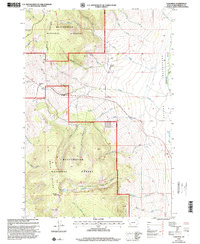
1997 Map of Tash Peak
USGS Topo · Published 2001About this map
Beaverhead National Forest defines this high-country landscape along the Big Hole Divide, where the waters of the Dillon Ranger District split toward disparate drainage systems. The eastern slopes descend into the Grasshopper Valley, a wide basin where Grasshopper Creek collects the flow from numerous tributaries like Pole Creek and Middle Creek. The map documents a rugged topography punctuated by high summits such as Harrison Peak and Tash Peak, with isolated water features like Harrison Lake tucked into the high basins. Settlement is sparse in this mountainous terrain, with the Circle-S Ranch serving as a primary named landmark of human presence amidst the complex network of mountain passes, including Big Hole Pass. This late-twentieth-century revision provides a clear record of the access roads and forest boundaries at a time when traditional ranching and public land management intersected in the Pioneer Mountains.
Find a feature on this map
35 named features on this map. Tap any name to fly to it.
Don’t see what you’re looking for? This feature index may not catch every label — zoom into the map to look around manually.
Map Details
Editions of this 1997 Tash Peak Map
This is the sole edition of this map. No revisions or reprints were ever made.
Other maps of this area

1955 · Dillon
USGS Topo · 1:250,000

1957 · Dillon
USGS Topo · 1:250,000

1958 · Dillon
USGS Topo · 1:250,000

1959 · Polaris
USGS Topo · 1:62,500

1959 · Grant
USGS Topo · 1:62,500

1962 · Dillon
USGS Topo · 1:250,000

1965 · Dillon
USGS Topo · 1:250,000

1978 · Butch Hill
USGS Topo · 1:24,000
1978 · Jackson Hill
USGS Topo · 1:24,000
1981 · Salmon
USGS Topo · 1:100,000