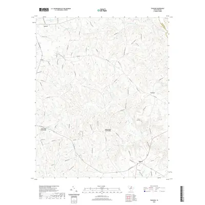
2020 Map of Taxahaw
USGS Topo · Published 2020About this map
Forty Acre Rock stands as a prominent natural landmark in this section of Lancaster County, surrounded by a landscape of small settlements and intersecting rural routes. The map detail highlights the clustering of community life at junctions like Fork Hill Crossroads and White Bluff Crossroads. Genealogists may find particular interest in the Fork Hill Cem and the various family-named roads such as Smokey Starnes Rd and Charlie Stacks Rd that weave through the terrain. The drainage of the land is defined by numerous waterways including Flat Creek and Wildcat Creek, which influence the local topography. This area, spanning from Buford to Midway, reflects a contemporary South Carolina landscape where industry and heritage meet, evidenced by labels like Mineral Mining Rd and Stamp Mill Rd alongside historic rural dwellings.
Find a feature on this map
87 named features on this map. Tap any name to fly to it.
Don’t see what you’re looking for? This feature index may not catch every label — zoom into the map to look around manually.
Map Details
Editions of this 2020 Taxahaw Map
This is the sole edition of this map. No revisions or reprints were ever made.
Other maps of this area

1941 · Spartanburg
USGS Topo · 1:250,000

1953 · Spartanburg
USGS Topo · 1:250,000

1960 · Spartanburg
USGS Topo · 1:250,000

1963 · Spartanburg
USGS Topo · 1:250,000

1964 · Spartanburg
USGS Topo · 1:250,000

1967 · Mount Pisgah
USGS Topo · 1:24,000

1968 · Heath Springs
USGS Topo · 1:24,000

1968 · Jefferson
USGS Topo · 1:24,000
1969 · Kershaw
USGS Topo · 1:24,000

1969 · Antioch
USGS Topo · 1:24,000