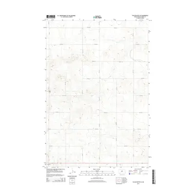
2014 Map of Taylor Butte SE
USGS Topo · Published 2014About this map
Rocky Ridge dominates the western portion of this landscape in Adams County, serving as a prominent geographical landmark amidst a network of rural section-line roads. The topography is defined by the drainage of Duck Cr, which meanders through the northeast, carving subtle relief into the prairie terrain. This 2014 survey documents the organized grid of the North Dakota countryside, where established routes like Cr-0119 and 2nd St NE provide access to the vast agricultural plots that characterize the region. In the southwestern corner of the quadrangle, the Hettinger Cem sits as a quiet waypoint for local history and genealogy, marking a significant site for the nearby community. The map's detailed contouring reveals the subtle rises and depressions typical of this part of the state, tracing the divide between high ridges and creek beds.
Find a feature on this map
19 named features on this map. Tap any name to fly to it.
Don’t see what you’re looking for? This feature index may not catch every label — zoom into the map to look around manually.
Map Details
Editions of this 2014 Taylor Butte SE Map
This is the sole edition of this map. No revisions or reprints were ever made.
Other maps of this area
1953 · Dickinson
USGS Topo · 1:250,000

1954 · Lemmon
USGS Topo · 1:250,000
1957 · Dickinson
USGS Topo · 1:250,000

1957 · Lemmon
USGS Topo · 1:250,000
1974 · Hettinger North
USGS Topo · 1:24,000
1974 · Hettinger South
USGS Topo · 1:24,000
1974 · Pearl Butte NW
USGS Topo · 1:24,000
1974 · Kid Rich Butte
USGS Topo · 1:24,000
1974 · Haynes
USGS Topo · 1:24,000
1980 · Mott
USGS Topo · 1:100,000