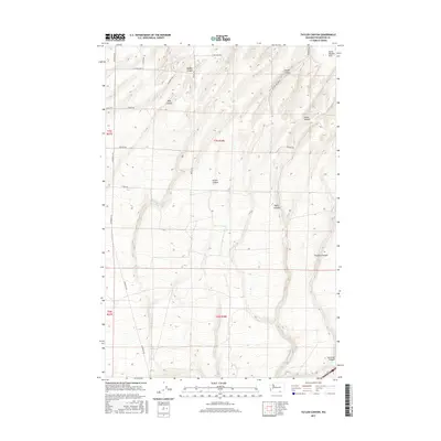
2017 Map of Taylor Canyon
USGS Topo · Published 2017About this map
Horse Heaven Hills dominates this 2017 survey of Benton County, where the high plateau is deeply incised by a series of significant drainage systems. The landscape is defined by the repetitive, parallel descent of Taylor Canyon, Badger Canyon, and Coyote Canyon as they carve their way through the southern Washington terrain. The map details a sophisticated network of section-line roads, including Plymouth Rd and Edwards Rd, which facilitate movement across this agrarian and topographical divide. Smaller draws like Straub Canyon and Amon Canyon illustrate the complex erosion patterns that characterize the region north of Fourmile Canyon. This topographic study provides a clear view of the land use and natural corridors established between the ridges, capturing the modern spatial organization of these high-desert hills.
Find a feature on this map
27 named features on this map. Tap any name to fly to it.
Don’t see what you’re looking for? This feature index may not catch every label — zoom into the map to look around manually.
Map Details
Editions of this 2017 Taylor Canyon Map
This is the sole edition of this map. No revisions or reprints were ever made.
Other maps of this area
1908 · Umatilla
USGS Topo · 1:125,000
1917 · Pasco
USGS Topo · 1:125,000
1953 · Pendleton
USGS Topo · 1:250,000
1953 · Walla Walla
USGS Topo · 1:250,000
1956 · Pendleton
USGS Topo · 1:250,000
1958 · Walla Walla
USGS Topo · 1:250,000
1962 · Hat Rock
USGS Topo · 1:24,000
1962 · Irrigon
USGS Topo · 1:24,000
1962 · Umatilla
USGS Topo · 1:24,000
1964 · Johnson Butte
USGS Topo · 1:24,000