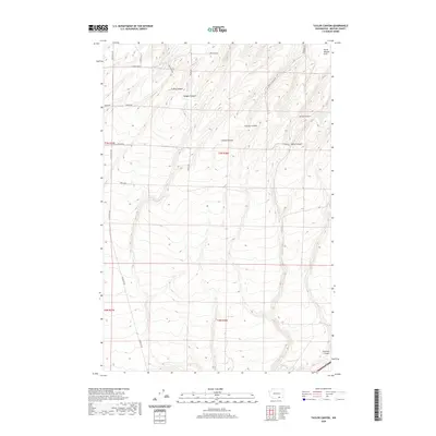
2020 Map of Taylor Canyon
USGS Topo · Published 2020About this map
Horse Heaven Hills define the northern landscape of this region, where deep drainage systems carve through the plateau toward the Columbia River basin. The terrain is characterized by a series of prominent ravines, including Taylor Canyon, Coyote Canyon, and Amon Canyon, which illustrate the complex topography south of the Tri-Cities area. While modern roads like Plymouth Rd and Coyote Canyon Rd provide access through the hills, the map preserves the names of earlier land divisions and family-named routes such as H Smith Rd and Bently Rd. The area between Badger Canyon and Fourmile Canyon shows a transition from high ridges to the gentler slopes of the lower canyon floors, revealing the historical importance of water drainage and natural corridors in determining the local road network.
Find a feature on this map
27 named features on this map. Tap any name to fly to it.
Don’t see what you’re looking for? This feature index may not catch every label — zoom into the map to look around manually.
Map Details
Editions of this 2020 Taylor Canyon Map
This is the sole edition of this map. No revisions or reprints were ever made.
Other maps of this area

1908 · Umatilla
USGS Topo · 1:125,000

1917 · Pasco
USGS Topo · 1:125,000

1953 · Pendleton
USGS Topo · 1:250,000

1953 · Walla Walla
USGS Topo · 1:250,000

1956 · Pendleton
USGS Topo · 1:250,000

1958 · Walla Walla
USGS Topo · 1:250,000

1962 · Hat Rock
USGS Topo · 1:24,000
1962 · Irrigon
USGS Topo · 1:24,000

1962 · Umatilla
USGS Topo · 1:24,000
1964 · Johnson Butte
USGS Topo · 1:24,000