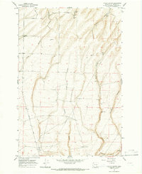
1965 Map of Taylor Canyon
USGS Topo · Published 1966About this map
The high, arid rangelands of southern Benton County are defined here by a series of deep north-south drainages including Badger Canyon, Taylor Canyon, and Coyote Canyon. In the mid-1960s, this landscape supported a sparse network of ranching infrastructure, where water was the most critical resource. The map documents several vital water sources such as Williams Wells, Idle Wells, Taylor Well, and Sweanys Well, which sustained livestock in this dry environment. Agricultural activity is further evidenced by various Storage Bins scattered across the uplands. Human passage through this terrain relied on unpaved routes like Plymouth Road, Smith Road, and Reese Road, often following the natural contours of the ridges. The presence of the Big Wells Pumphouse and an extensive Pipeline illustrate the engineering required to manage water distribution across the expansive Straub Canyon and Prospect Canyon areas.
Find a feature on this map
27 named features on this map. Tap any name to fly to it.
Don’t see what you’re looking for? This feature index may not catch every label — zoom into the map to look around manually.
Map Details
Editions of this 1965 Taylor Canyon Map
This is the sole edition of this map. No revisions or reprints were ever made.
Other maps of this area

1908 · Umatilla
USGS Topo · 1:125,000

1917 · Pasco
USGS Topo · 1:125,000

1953 · Pendleton
USGS Topo · 1:250,000

1953 · Walla Walla
USGS Topo · 1:250,000

1956 · Pendleton
USGS Topo · 1:250,000

1958 · Walla Walla
USGS Topo · 1:250,000

1962 · Hat Rock
USGS Topo · 1:24,000
1962 · Irrigon
USGS Topo · 1:24,000

1962 · Umatilla
USGS Topo · 1:24,000
1964 · Johnson Butte
USGS Topo · 1:24,000