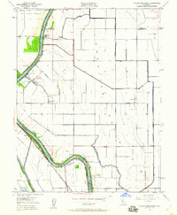
1950 Map of Taylor Monument
USGS Topo · Published 1960About this map
The Sacramento River carves a sharp, serpentine path through the heart of the American Basin, defining the agricultural and industrial character of this region during the post-war era. The landscape is heavily engineered for water management, featuring a dense network of levees and drainage channels including the El Centro Drainage Canal and the North Drainage Canal. Significant infrastructure like the Prichard Lake Pumping Plant and Elkhorn Pumping Plant demonstrates the ongoing effort to control the basin's hydrology for farming and flood protection.
Find a feature on this map
38 named features on this map. Tap any name to fly to it.
Don’t see what you’re looking for? This feature index may not catch every label — zoom into the map to look around manually.
Map Details
Editions of this 1950 Taylor Monument Map
This is the sole edition of this map. No revisions or reprints were ever made.
Other maps of this area

1891 · Sacramento
USGS Topo · 1:125,000

1892 · Sacramento
USGS Topo · 1:125,000

1893 · Sacramento
USGS Topo · 1:125,000

1902 · Fairoaks
USGS Topo · 1:62,500

1907 · Davisville
USGS Topo · 1:62,500

1910 · Knights Landing
USGS Topo · 1:31,680

1910 · Vernon
USGS Topo · 1:31,680

1910 · Pleasant Grove
USGS Topo · 1:31,680

1911 · Brighton
USGS Topo · 1:31,680

1911 · Arcade
USGS Topo · 1:31,680