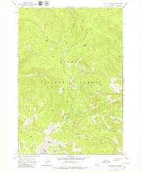
1963 Map of Taylor Mountain
USGS Topo · Published 1979About this map
The boundary between Lemhi and Custer counties cuts across this high-elevation landscape, where the Salmon National Forest meets the Challis Nat Forest. The terrain is defined by dramatic peaks and alpine hydrology, centered on the prominent summit of Taylor Mountain and the high ridges of Moyer Peak. These peaks feed a complex network of drainage systems, including South Fork Iron Creek and the headwaters of the Middle Fork Hat Creek. Outdoor recreation and land management are evident through the presence of the Iron Lake Campground situated beside Iron Lake, accessible by the winding Salmon River Road. The map also captures several high-meadow and spring features such as Squawboard Meadow and Dishrag Spring, illustrating the varied topography of this wilderness area during the early 1960s.
Find a feature on this map
23 named features on this map. Tap any name to fly to it.
Don’t see what you’re looking for? This feature index may not catch every label — zoom into the map to look around manually.
Map Details
Editions of this 1963 Taylor Mountain Map
2 editions found
Other maps of this area

1950 · Blackbird Mtn
USGS Topo · 1:62,500

1950 · Leesburg
USGS Topo · 1:62,500

1951 · Leesburg
USGS Topo · 1:62,500

1951 · Blackbird Mtn
USGS Topo · 1:62,500

1956 · Elk City
USGS Topo · 1:250,000

1957 · Challis
USGS Topo · 1:250,000

1960 · Elk City
USGS Topo · 1:250,000

1960 · Challis
USGS Topo · 1:250,000
1962 · Degan Mtn
USGS Topo · 1:24,000

1963 · Challis
USGS Topo · 1:250,000