
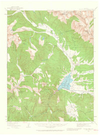
1934 Map of Taylor Park
USGS Topo · Published 1968About this map
The high-altitude mining and ranching economy of the Sawatch Mountains is captured here during the mid-1930s, a period when remote extraction operations and high-country cattle camps defined the landscape of the Gunnison National Forest. Centered on the Taylor Park Reservoir, the map documents a network of industrial sites including the Enterprise Mine, Forest Hill Mine, and Pieplant Mine, many of which were supported by dedicated processing facilities like the Pieplant Mill.
Find a feature on this map
75 named features on this map. Tap any name to fly to it.
Don’t see what you’re looking for? This feature index may not catch every label — zoom into the map to look around manually.
Map Details
Editions of this 1934 Taylor Park Map
3 editions found
Other maps of this area

1888 · Crested Butte
USGS Topo · 1:62,500

1889 · Crested Butte
USGS Topo · 1:62,500

1889 · Leadville
USGS Topo · 1:125,000

1891 · Leadville
USGS Topo · 1:125,000

1893 · Crested Butte
USGS Topo · 1:62,500

1893 · Aspen
USGS Topo · 1:62,500

1895 · Aspen
USGS Topo · 1:62,500

1909 · Mount Jackson
USGS Topo · 1:125,000

1911 · Mount Jackson
USGS Topo · 1:125,000
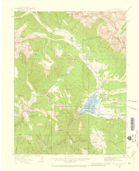
1934 · Taylor Park
USGS Topo · 1:62,500