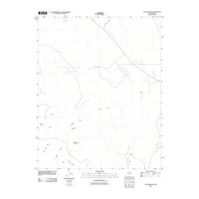
2010 Map of Taylor Ranch
USGS Topo · Published 2010About this map
The high desert landscape of Sandoval County is defined here by several large ranching operations and drainage networks. Isolated settlements such as Taylor Ranch and the Alexander Ranch are connected by secondary routes, including Indian Service Route 37 and W Lovinia Woods. The terrain transitions from the San Isidro Valley toward the prominent Ceja Pelon Mesa, marked by numerous seasonal drainages such as Arroyo Pelon and Arroyo Penistaja. Evidence of water management in this arid environment is visible at the Encino Detention Dam Number 63, while the Apache Indian Res boundary indicates the intersection of tribal lands with surrounding ranch holdings. Industrial history is represented by the Crook Number Two Group, suggesting mining activity near the settlement of Landers.
Find a feature on this map
16 named features on this map. Tap any name to fly to it.
Don’t see what you’re looking for? This feature index may not catch every label — zoom into the map to look around manually.
Map Details
Editions of this 2010 Taylor Ranch Map
This is the sole edition of this map. No revisions or reprints were ever made.
Other maps of this area

1883 · Mt. Taylor
USGS Topo · 1:250,000

1886 · Mt. Taylor
USGS Topo · 1:250,000

1889 · Largo
USGS Topo · 1:250,000

1892 · Mt. Taylor
USGS Topo · 1:250,000

1895 · Largo
USGS Topo · 1:250,000

1899 · Mt. Taylor
USGS Topo · 1:250,000

1954 · Aztec
USGS Topo · 1:250,000

1958 · Aztec
USGS Topo · 1:250,000

1958 · Albuquerque
USGS Topo · 1:250,000
1961 · Ojo Encino Mesa
USGS Topo · 1:24,000