
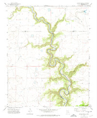
1965 Map of Taylor Springs
USGS Topo · Published 1967About this map
Taylor Springs sits near the western edge of this 1965 survey, positioned along the banks of the Canadian River in Colfax County. This high-plains landscape is defined by the intersection of historic transit and natural watercourses, most notably where segments of the Santa Fe Trail cut across the drainage of Chico Creek. The topography reveals a mix of plateau land and deeply carved arroyos, including Arroyo Jaritas and the Arroyo leading toward Middle Lake. Evidence of early cattle ranching and land management is visible through the intricate network of fence lines and localized water sources like the Water Tank and several natural Springs. The eastern boundary of the Beaubien and Miranda grant marks the western portion of the sheet, reflecting the complex land-grant history of Northern New Mexico. Small-scale infrastructure such as a Gaging Sta on the river and a lone Cem suggest the sparse, rural nature of the settlement at this time.
Find a feature on this map
14 named features on this map. Tap any name to fly to it.
Don’t see what you’re looking for? This feature index may not catch every label — zoom into the map to look around manually.
Map Details
Editions of this 1965 Taylor Springs Map
This is the sole edition of this map. No revisions or reprints were ever made.
Other maps of this area

1954 · Raton
USGS Topo · 1:250,000

1958 · Raton
USGS Topo · 1:250,000

1964 · Stony Lake
USGS Topo · 1:24,000

1965 · Sauble Circle Dot Ranch
USGS Topo · 1:24,000

1965 · Abbott NW
USGS Topo · 1:24,000

1965 · French
USGS Topo · 1:24,000

1965 · Abbott
USGS Topo · 1:24,000

1965 · Springer
USGS Topo · 1:24,000

1971 · Abbott Lake
USGS Topo · 1:24,000
1972 · Jaritas Ranch
USGS Topo · 1:24,000