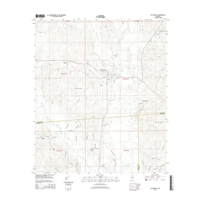
2015 Map of Taylorsville
USGS Topo · Published 2015About this map
Taylorsville serves as the central hub of this Mississippi landscape, where the Leaf River and Oakohay Creek systems converge. The settlement pattern shows a concentration of activity along the major thoroughfares, including Central St and E Moore St, while smaller communities like Wisner and Gambrell sit on the periphery. The geography is defined by its waterways and their tributaries, such as Fisher Cr and Lyon Cr, which dictate the placement of local roads and property boundaries. Genealogists and local historians will find significant value in the distribution of family and community burial sites across the area, from Oakohay Cem in the west to Hinton Cem in the east. The presence of Smith County Airport southwest of the main town indicates the area's modern infrastructure development, while traditional land divisions are still visible through the established township and range lines.
Find a feature on this map
92 named features on this map. Tap any name to fly to it.
Don’t see what you’re looking for? This feature index may not catch every label — zoom into the map to look around manually.
Map Details
Editions of this 2015 Taylorsville Map
This is the sole edition of this map. No revisions or reprints were ever made.
Other maps of this area

1953 · Hattiesburg
USGS Topo · 1:250,000

1958 · Hattiesburg
USGS Topo · 1:250,000

1965 · Hebron
USGS Topo · 1:24,000

1965 · Hot Coffee
USGS Topo · 1:24,000

1974 · Soso
USGS Topo · 1:24,000

1974 · Collins
USGS Topo · 1:24,000
1974 · Bay Springs
USGS Topo · 1:24,000
1975 · Cohay
USGS Topo · 1:24,000

1975 · Taylorsville
USGS Topo · 1:24,000

1975 · Mize
USGS Topo · 1:24,000