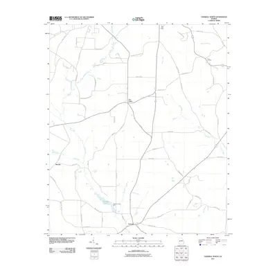
2011 Map of Tazewell North
USGS Topo · Published 2011About this map
Tazewell sits at the southern edge of this Marion County landscape, serving as a focal point for a network of rural routes including County Rd-140 and County Rd-141. The terrain is defined by its drainages, with Shoal Creek winding through the western half of the quadrangle to feed into Chapman Lake, which is contained by the Chapman Lake Dam. Further north, the junction at Five Points anchors the central region, while Blueville marks the western boundary. Significant genealogical landmarks are found throughout the area, such as Trinity Cemetery in the northeast and the Mauk Post Office near the northern border. The map illustrates a contemporary rural Georgian landscape where modern roads like Bridle Path Ln and Egret Ct weave between traditional watercourses like Cedar Creek and Gin Creek, reflecting the gradual residential development of former agricultural lands.
Find a feature on this map
52 named features on this map. Tap any name to fly to it.
Don’t see what you’re looking for? This feature index may not catch every label — zoom into the map to look around manually.
Map Details
Editions of this 2011 Tazewell North Map
This is the sole edition of this map. No revisions or reprints were ever made.
Other maps of this area

1907 · Talbotton
USGS Topo · 1:125,000

1950 · Geneva
USGS Topo · 1:24,000

1950 · Buena Vista NE
USGS Topo · 1:24,000

1950 · Buena Vista
USGS Topo · 1:24,000

1950 · Buena Vista
USGS Topo · 1:62,500

1950 · Talbotton
USGS Topo · 1:62,500

1955 · Buena Vista
USGS Topo · 1:24,000

1955 · Buena Vista NE
USGS Topo · 1:24,000
1955 · Geneva
USGS Topo · 1:24,000
1955 · Talbotton
USGS Topo · 1:62,500