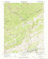
1968 Map of Tazewell North
USGS Topo · Published 1971About this map
The Clinch River flows through the southern portion of this landscape, anchoring the bustling rail corridor of Tazewell and North Tazewell. This late-1960s survey documents a region defined by the industry of the Norfolk and Western railroad, which snakes through the steep valleys to serve the extensive strip mines and tipples of the northern coal country. The border between West Virginia and Virginia cuts across the rugged terrain near Bishop, where the topography is split by the formidable Stony Ridge Divide. Local life is etched into the hollows, from the community at Adria to the Lila Chapel and numerous family cemeteries like Maplewood Cem. The map reveals the intricate water network of Jacobs Fork and Dry Fork, illustrating how settlement patterns followed these vital narrow corridors between the ridges.
Find a feature on this map
64 named features on this map. Tap any name to fly to it.
Don’t see what you’re looking for? This feature index may not catch every label — zoom into the map to look around manually.
Map Details
Editions of this 1968 Tazewell North Map
2 editions found
Other maps of this area

1887 · Pocahontas
USGS Topo · 1:125,000

1891 · Tazewell
USGS Topo · 1:125,000

1891 · Pocahontas
USGS Topo · 1:125,000

1894 · Pocahontas
USGS Topo · 1:125,000

1895 · Tazewell
USGS Topo · 1:125,000

1895 · Pocahontas
USGS Topo · 1:125,000

1897 · Tazewell
USGS Topo · 1:125,000

1909 · Pocahontas Special
USGS Topo · 1:48,000

1911 · Pocahontas Special
USGS Topo · 1:62,500

1912 · Pounding Mill
USGS Topo · 1:62,500