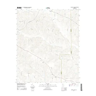
2014 Map of Tazewell South
USGS Topo · Published 2014About this map
Tazewell sits at the northern edge of this West Georgia landscape, where agricultural lands meet the dense network of tributaries feeding into Muckalee Cr and Oochee Cr. The settlement patterns here follow the high ground between these drainages, with the small community of Doyle and its corresponding Doyle Cem positioned along the central corridor of Ga-26. Moving south toward Putnam, the terrain is defined by numerous named branches like Blackshear Br and Walton Br. This 2014 survey reveals a rural landscape deeply tied to family and local history, as evidenced by several smaller water bodies such as Cook Pond and Miller Lake, alongside established church-affiliated landmarks like New Hope Cem and Corinth Cem. The boundary between Marion and Schley counties runs vertically through the eastern portion of the map, separating the creek-bottom lands from the upland ridges.
Find a feature on this map
59 named features on this map. Tap any name to fly to it.
Don’t see what you’re looking for? This feature index may not catch every label — zoom into the map to look around manually.
Map Details
Editions of this 2014 Tazewell South Map
This is the sole edition of this map. No revisions or reprints were ever made.
Other maps of this area

1950 · Buena Vista NE
USGS Topo · 1:24,000

1950 · Buena Vista
USGS Topo · 1:24,000

1950 · Buena Vista
USGS Topo · 1:62,500

1955 · Buena Vista
USGS Topo · 1:24,000

1955 · Buena Vista NE
USGS Topo · 1:24,000
1955 · Buena Vista
USGS Topo · 1:62,500

1955 · Phenix City
USGS Topo · 1:250,000

1957 · Phenix City
USGS Topo · 1:250,000

1958 · Phenix City
USGS Topo · 1:250,000

1971 · Rupert
USGS Topo · 1:24,000