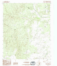
1990 Map of Teacup Mountain
USGS Topo · Published 1995About this map
The Pease River cuts through the high plains of North Texas, forming the boundary between Hardeman and Foard counties. This late-twentieth-century landscape is defined by the canyon systems of Bowley and Sloans, alongside prominent natural landmarks like Teacup Mountain and Sugarloaf Mountain. The northeastern corner of the map contains the development of Copper Breaks State Park, including Lake Copper Breaks and a dedicated Campground. The terrain is marked by a network of drainage systems such as Mud Creek, Cedar Creek, and Raggedy Creek, illustrating the complex hydrology of the region. A solitary Landing Strip and a series of canals indicate local infrastructure, while Sloans Springs provides a specific point of interest for those studying the area's natural water sources and historical land use.
Find a feature on this map
20 named features on this map. Tap any name to fly to it.
Don’t see what you’re looking for? This feature index may not catch every label — zoom into the map to look around manually.
Map Details
Editions of this 1990 Teacup Mountain Map
This is the sole edition of this map. No revisions or reprints were ever made.
Other maps of this area

1927 · Quanah 3-a
USGS Topo · 1:48,000

1927 · Quanah 3-b
USGS Topo · 1:48,000

1932 · Vivian
USGS Topo · 1:62,500

1954 · Wichita Falls
USGS Topo · 1:250,000

1955 · Lawton
USGS Topo · 1:250,000

1958 · Wichita Falls
USGS Topo · 1:250,000

1958 · Medicine Mound
USGS Topo · 1:62,500

1960 · Teacup Mountain
USGS Topo · 1:62,500

1966 · Crowell
USGS Topo · 1:24,000
1968 · Boiling Spring
USGS Topo · 1:24,000