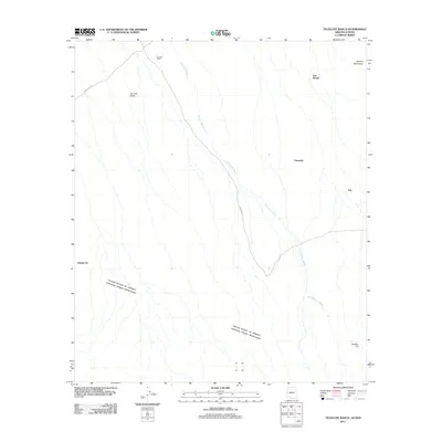
2011 Map of Tecolote Ranch
USGS Topo · Published 2011About this map
Tecolote Ranch serves as a primary landmark in this desert landscape, situated at the head of the Tecolote Valley. The terrain is defined by the braided drainage of Chukut Kuk Wash, which bisects the quadrangle as it flows southward toward the international border. In the southern portion of the sheet, the boundary between the United States and Mexico is clearly delineated across the open basin. Small settlements and points of interest such as San Rafael, Vakamok, and Itak are linked by primitive routes including Indian Rte 12 and Indian Rte 2. The elevation rises toward the eastern and southern edges of the map, anchored by the Alvarez Mountains and the solitary rise of Wolfley Hill. This survey captures the sparse infrastructure and remote character of the borderlands within the Chukut Kuk District.
Find a feature on this map
12 named features on this map. Tap any name to fly to it.
Don’t see what you’re looking for? This feature index may not catch every label — zoom into the map to look around manually.
Map Details
Editions of this 2011 Tecolote Ranch Map
This is the sole edition of this map. No revisions or reprints were ever made.
Other maps of this area

1941 · Vamori
USGS Topo · 1:62,500

1941 · Sells
USGS Topo · 1:62,500

1943 · Sells
USGS Topo · 1:62,500

1943 · Fresnal
USGS Topo · 1:125,000

1943 · Vamori
USGS Topo · 1:62,500

1954 · Sonoyta
USGS Topo · 1:250,000

1956 · Nogales
USGS Topo · 1:250,000

1958 · Nogales
USGS Topo · 1:250,000

1959 · Nogales
USGS Topo · 1:250,000

1963 · Gu Oidak
USGS Topo · 1:62,500
Featured Places
- Itak, Chukut Kuk District
- San Rafael, Chukut Kuk District
- Vakamok, Chukut Kuk District
- Chukut Kuk District, AZ