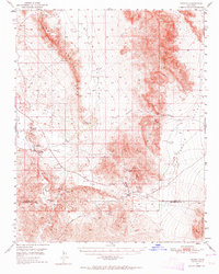
1950 Map of Tecopa
USGS Topo · Published 1964About this map
Gunsight Mine and Noonday Mine anchor a high-desert landscape defined by mid-century mineral extraction and deep history in this 1950 field-checked survey. The map records a critical transition for the region, where a Dismantled Railroad follows the path of the Amargosa River, signaling the end of one industrial era while Tecopa Hot Springs and Tecopa suggest the area's enduring local centers. The terrain is dominated by the Resting Spring Range and the Nopah Range, separated by the broad expanse of Chicago Valley. This sheet captures the intersection of early pioneer routes and modern mining, specifically noting the historic Spanish Trail as it crosses through Emigrant Pass. Water remains the central feature of the arid environment, with reliable points like Resting Spr, China Ranch, and Willow Spring providing essential waypoints for travelers and miners alike.
Find a feature on this map
27 named features on this map. Tap any name to fly to it.
Don’t see what you’re looking for? This feature index may not catch every label — zoom into the map to look around manually.
Map Details
Editions of this 1950 Tecopa Map
3 editions found

Other maps of this area

1907 · Las Vegas
USGS Topo · 1:250,000

1908 · Furnace Creek
USGS Topo · 1:250,000

1908 · Las Vegas
USGS Topo · 1:250,000

1910 · Furnace Creek
USGS Topo · 1:250,000

1910 · Ivanpah
USGS Topo · 1:250,000

1912 · Ivanpah
USGS Topo · 1:250,000

1933 · Avawatz Mountains
USGS Topo · 1:250,000

1940 · Eagle Tank
USGS Topo · 1:62,500

1942 · Ivanpah
USGS Topo · 1:250,000

1947 · Trona
USGS Topo · 1:250,000