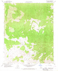
1966 Map of Tehachapi NE
USGS Topo · Published 1967About this map
Caves (Pictographs) and the Horse Canyon Agate Beds define the high desert character of this Kern County landscape as it was recorded in the mid-1960s. The terrain is a network of drainage canyons and prominent peaks, including Sugarloaf Mtn and Cache Peak, where water sources like Sweetwater Spr and Goodwater Spring were critical markers. Traces of human activity are scattered across the quadrangle, from several labeled Quarry and Prospect sites to a lonely Cem near the confluence of Sand Creek and Cache Creek. The mapping reveals a remote area primarily navigated by a series of Jeep Trails, showing the intersection of geological exploration and ancient archaeological sites before more modern developments changed the local footprint. The labeling of a Claypit and various Quarries suggests small-scale industrial interest in the mineral resources found within these arid foothills.
Find a feature on this map
32 named features on this map. Tap any name to fly to it.
Don’t see what you’re looking for? This feature index may not catch every label — zoom into the map to look around manually.
Map Details
Editions of this 1966 Tehachapi NE Map
3 editions found
Other maps of this area

1915 · Mojave
USGS Topo · 1:125,000

1943 · Tehachapi
USGS Topo · 1:62,500

1943 · Cross Mountain
USGS Topo · 1:62,500

1943 · Emerald Mtn
USGS Topo · 1:62,500

1943 · Mojave
USGS Topo · 1:62,500

1947 · Mojave
USGS Topo · 1:24,000

1948 · Bakersfield
USGS Topo · 1:250,000

1955 · Bakersfield
USGS Topo · 1:250,000

1956 · Bakersfield
USGS Topo · 1:250,000
1956 · Mojave
USGS Topo · 1:62,500