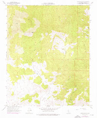
1966 Map of Tehachapi NE
USGS Topo · Published 1976About this map
Sugarloaf Mtn and Cache Peak dominate this landscape in the southern Sierra Nevada, where the desert-edge terrain is marked by ancient and industrial human activity. Along the complex drainage of Sand Canyon and Cache Canyon, the map reveals a history of resource extraction through numerous quarries, prospects, and a Claypit. This 1966 survey, with 1973 photogrammetric revisions, captures a transitional environment where seasonal water sources like Sweetwater Spr and Goodwater Spring were vital to local development.
Find a feature on this map
33 named features on this map. Tap any name to fly to it.
Don’t see what you’re looking for? This feature index may not catch every label — zoom into the map to look around manually.
Map Details
Editions of this 1966 Tehachapi NE Map
3 editions found
Other maps of this area

1915 · Mojave
USGS Topo · 1:125,000

1943 · Tehachapi
USGS Topo · 1:62,500

1943 · Cross Mountain
USGS Topo · 1:62,500

1943 · Emerald Mtn
USGS Topo · 1:62,500

1943 · Mojave
USGS Topo · 1:62,500

1947 · Mojave
USGS Topo · 1:24,000

1948 · Bakersfield
USGS Topo · 1:250,000

1955 · Bakersfield
USGS Topo · 1:250,000

1956 · Bakersfield
USGS Topo · 1:250,000
1956 · Mojave
USGS Topo · 1:62,500