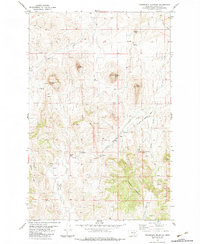
1983 Map of Telegraph Mountain
USGS Topo · Published 1983About this map
St Peter stands as a focal point in this high-plains landscape where the southern reaches of the Sullivan Valley meet the rising slopes of Telegraph Mountain. This 1983 survey illustrates a transition from established mission life to the open ranching country defined by the Birdtail Divide. The presence of Sullivan School and the Cem near the St Peter Mission Road suggests a community structure built around education and faith in a territory otherwise dominated by prominent landforms like Lionhead Butte and Haystack Butte. The drainage patterns of Mission Creek and Sullivan Creek reveal the essential water sources that dictate movement and settlement in this portion of Cascade County. A network of unimproved roads and fence lines, meticulously recorded, provides a clear view of the rural property boundaries and infrastructure serving the local agricultural economy during the late twentieth century.
Find a feature on this map
22 named features on this map. Tap any name to fly to it.
Don’t see what you’re looking for? This feature index may not catch every label — zoom into the map to look around manually.
Map Details
Editions of this 1983 Telegraph Mountain Map
This is the sole edition of this map. No revisions or reprints were ever made.
Other maps of this area

1886 · Great Falls
USGS Topo · 1:250,000

1943 · Hogan
USGS Topo · 1:125,000

1954 · Great Falls
USGS Topo · 1:250,000

1955 · Choteau
USGS Topo · 1:250,000

1957 · Choteau
USGS Topo · 1:250,000

1957 · Great Falls
USGS Topo · 1:250,000

1958 · Choteau
USGS Topo · 1:250,000

1960 · Simms
USGS Topo · 1:62,500

1961 · Hardy
USGS Topo · 1:24,000
1961 · Coburn Mountain
USGS Topo · 1:24,000