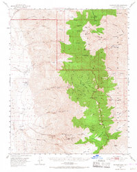
1952 Map of Telescope Peak
USGS Topo · Published 1968About this map
Ballarat sits at the edge of the Panamint Valley floor, serving as a gateway to the high elevations of the Panamint Range during the mid-twentieth century. This era of the Death Valley National Monument reveals a landscape defined by mining activity and remote outposts. Significant resource extraction is evident at the World Beater Mine and Radcliff Mine in the southern canyons, while higher elevations like Telescope Peak and Sentinel Peak dominate the topography.
Find a feature on this map
64 named features on this map. Tap any name to fly to it.
Don’t see what you’re looking for? This feature index may not catch every label — zoom into the map to look around manually.
Map Details
Editions of this 1952 Telescope Peak Map
4 editions found

Other maps of this area

1908 · Furnace Creek
USGS Topo · 1:250,000

1908 · Ballarat
USGS Topo · 1:250,000

1910 · Furnace Creek
USGS Topo · 1:250,000

1913 · Ballarat
USGS Topo · 1:250,000

1915 · Searles Lake
USGS Topo · 1:250,000

1933 · Avawatz Mountains
USGS Topo · 1:250,000

1947 · Trona
USGS Topo · 1:250,000

1948 · Trona
USGS Topo · 1:250,000

1948 · Death Valley
USGS Topo · 1:250,000

1949 · Trona
USGS Topo · 1:62,500