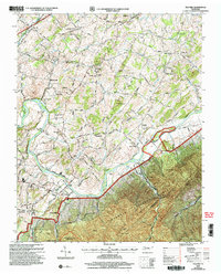
2003 Map of Telford
USGS Topo · Published 2004About this map
The Washington College campus and the surrounding agricultural landscape of Washington County define this region at the start of the 21st century. The terrain transitions from the rolling valley floor near Telford and Broylesville into the steep, forested slopes of the Cherokee National Forest and the Sampson Mountain Wilderness. Local history is deeply embedded in the land, from the Washington College P O and Sta along the Norfolk Southern railroad to the Greeneville Iron Furnace (Documentary Site) tucked away in the southern hills. The Nolichucky River winds through the center of the map, past landmarks like Mitchell Bluff and the Jackson Islands, while smaller communities such as New Victory and Conklin serve as local anchors. The presence of the Peach Orchard Mine and various small cemeteries scattered across the ridges reflects the area's long-standing reliance on the land's natural resources and the deep roots of its resident families.
Find a feature on this map
60 named features on this map. Tap any name to fly to it.
Don’t see what you’re looking for? This feature index may not catch every label — zoom into the map to look around manually.
Map Details
Editions of this 2003 Telford Map
This is the sole edition of this map. No revisions or reprints were ever made.
Other maps of this area

1891 · Roan Mountain
USGS Topo · 1:125,000

1892 · Greeneville
USGS Topo · 1:125,000

1894 · Roan Mountain
USGS Topo · 1:125,000

1896 · Greeneville
USGS Topo · 1:125,000

1904 · Roan Mountain
USGS Topo · 1:125,000

1904 · Greeneville
USGS Topo · 1:125,000

1935 · Chestoa
USGS Topo · 1:24,000

1935 · Leesburg
USGS Topo · 1:24,000

1935 · Erwin
USGS Topo · 1:24,000

1935 · Fall Branch
USGS Topo · 1:48,000