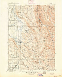
1906 Map of Telocaset
USGS Topo · Published 1948About this map
The Grande Ronde Valley serves as a vital agricultural and transit corridor in this 1904 survey, where the Union Pacific railroad and the historic Oregon Trail converge near Union. The settlement pattern follows the valley floors, with small hubs like Cove, Alicel, and Imbler situated at the base of the surrounding peaks. Significant engineering of the landscape is evident through the State Ditch and Coughanour Ditch, reflecting early 20th-century water management for irrigation. To the east, the rugged peaks of the Wallowa National Forest rise sharply, including Mt Fanny and Mt Harris, while local landmarks like Hot Lake and Medical Springs indicate the importance of geothermal features to the era's commerce and tourism. The map captures the transition from the irrigated valley floors to the high timbered country of the Wallowa Mountains.
Find a feature on this map
93 named features on this map. Tap any name to fly to it.
Don’t see what you’re looking for? This feature index may not catch every label — zoom into the map to look around manually.
Map Details
Editions of this 1906 Telocaset Map
3 editions found
Other maps of this area

1901 · Baker City
USGS Topo · 1:125,000

1901 · Sumpter
USGS Topo · 1:125,000

1906 · Telocaset
USGS Topo · 1:125,000

1915 · Pine
USGS Topo · 1:125,000

1953 · Pendleton
USGS Topo · 1:250,000

1954 · Eagle Cap
USGS Topo · 1:62,500

1955 · Baker
USGS Topo · 1:250,000

1955 · Grangeville
USGS Topo · 1:250,000

1955 · Canyon City
USGS Topo · 1:250,000

1956 · Pendleton
USGS Topo · 1:250,000