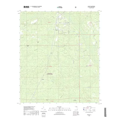
2018 Map of Telogia
USGS Topo · Published 2018About this map
Apalachicola National Forest dominates this section of Liberty County, where the sprawling pine flatwoods are dissected by an intricate network of narrow waterways and named branches. Small settlements like Telogia and Clio appear as clusters of activity along the corridor of Co Rd 67, providing a stark contrast to the deep woods of Big Thick. The landscape is heavily influenced by its hydrology, with numerous named drains such as Butcherknife Br, Western Br, and McCoy Branch feeding into the larger course of Telogia Creek. Local history is preserved in small, rural burial grounds including Old Burnoff Cem and Saint Marys Cem, which are scattered throughout the forest. The presence of Conners Ford and several island features like Brushy Islands and Indian Creek Islands reveals the traditional points of navigation and unique terrain within this managed timber and conservation area.
Find a feature on this map
62 named features on this map. Tap any name to fly to it.
Don’t see what you’re looking for? This feature index may not catch every label — zoom into the map to look around manually.
Map Details
Editions of this 2018 Telogia Map
This is the sole edition of this map. No revisions or reprints were ever made.
Other maps of this area

1943 · Lake Talquin
USGS Topo · 1:62,500

1944 · Queens Bay
USGS Topo · 1:24,000

1945 · Smith Creek
USGS Topo · 1:31,680

1945 · Hosford
USGS Topo · 1:31,680

1945 · Bristol
USGS Topo · 1:31,680

1945 · Woods
USGS Topo · 1:31,680

1945 · Telogia
USGS Topo · 1:24,000

1946 · Queens Bay
USGS Topo · 1:31,680

1946 · Telogia
USGS Topo · 1:31,680
1946 · Wilma
USGS Topo · 1:31,680