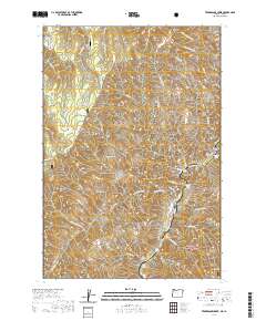
2020 Map of Temperance Creek
USGS Topo · Published 2020About this map
Snake River geography dominates this borderland survey where the Wallowa National Forest and Nez Perce National Forest meet. The river corridor, protected as the Snake Wild and Scenic River, features distinct river bars like Little Bar and High Bar, which served as critical landing points in this deep canyon environment. Human activity is evidenced by remote outposts such as Mikes Cabin and Cow Camp, while the Big Bar Airport provides a modern, though isolated, connection to the outside world. To the west, the landscape rises toward high ridges including Wing Ridge and Summit Ridge, traversed by the Western Rim-Natl Recreation trail. Notable landmarks like Suicide Point and Slaughter Gulch hint at the local lore and difficult passage through these canyons, while Temperance Creek drains the central interior.
Find a feature on this map
80 named features on this map. Tap any name to fly to it.
Don’t see what you’re looking for? This feature index may not catch every label — zoom into the map to look around manually.
Map Details
Editions of this 2020 Temperance Creek Map
This is the sole edition of this map. No revisions or reprints were ever made.
Other maps of this area

1922 · He Devil
USGS Topo · 1:48,000

1938 · Riggins
USGS Topo · 1:96,000

1945 · Riggins
USGS Topo · 1:125,000

1954 · Kernan Point
USGS Topo · 1:62,500

1955 · Grangeville
USGS Topo · 1:250,000

1957 · He Devil
USGS Topo · 1:62,500

1959 · Grangeville
USGS Topo · 1:250,000

1963 · Kirkwood Creek
USGS Topo · 1:24,000

1963 · Grave Point
USGS Topo · 1:24,000
1964 · Kessler Creek
USGS Topo · 1:24,000